

 Schwarzer Schöps
 Petite Glane
 Cechticky
 Cherio
 Dotnuvele
 Dviete
 Hobol
Hobol La Wimbe
 Pesnica
 Upper Zglowiaczka
 Sävjaan
Meet Our Case Studies vol. 4
The case study area of the Upper Zgłowiączka catchment is located in the north central Poland, in Kuyavian-Pomeranian province. The catchment area upstream of Lake Głuszyńskie occupies 150 km2. Due to highly productive soils, arable land prevails in the landscape. Among the main crops are cereals (wheat), maize, oilseed rape, sugar beet, alfalfa, vegetables and herbal crops. An increasing area is covered by catch crops. The region lacks precipitation, with the annual totals on average 500 mm and 300 mm in the growing season (Fig. 1), being the lowest in Poland. The area is characterized by a very high temporal variability of pluvial and hydrological conditions. In wet periods the drainage system (open ditches and subsurface tiles) drains excess water. Natural hydrographic network is very poor. The main challenges are increasing water deficits for crops and excessive nitrate concentrations in streams (Fig. 2). Additionally, the soil in the catchment is susceptible to wind and water erosion. Irrigation using mainly aquifer as a water source has been developing in recent years in response to more frequent droughts.
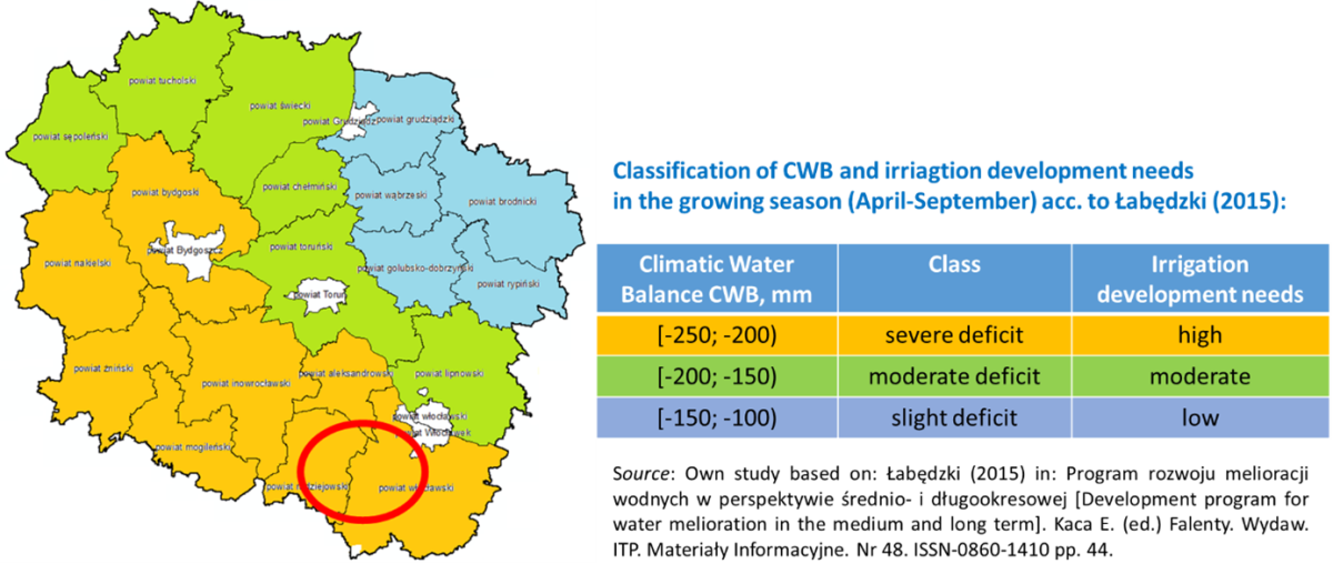
Fig. 1 Climatic water balance (CBW) in the Kuyavian-Pomeranian province (April-September)

Fig. 2 Nitrate concentration (NO3-N) in Upper Zgłowiączka river as monthly average values calculated based on 3,500 samples taken in the years 2007-2022. Source: Study based on own measurements carried out in the Samszyce station.
See description of the Upper Zgłowiączka case study on the OPTAIN website.

Fig. 3. Upper Zgłowiączka river (also called Głuszyński Canal) with the character of a mid-field ditch without a developed valley – no buffer zone (W. Kasperska-Wołowicz).

Fig. 4. Upper Zgłowiączka river inflow to Lake Głuszynskie– one of the sampling points (W. Kasperska-Wołowicz)
Installed equipment
Monitoring of agro-hydro-meteorological conditions has been conducted in the Zgłowiączka river catchment by ITP-PIB since 2008. The research station located in Samszyce is equipped with the automatic weather station (Fig. 6) and stationary refrigeration sampler (Fig. 7). Weather conditions (temperature and air humidity, solar radiation, wind speed and precipitation) have been measured since 2012. In this place monitoring of the surface waters quality in terms of pollutants from agriculture (nitrates and phosphates) is being carried out with a daily sampling step. Water levels in the river near the research station is also being continuously monitored.Based on water samples from the Zgłowiączka catchment and drainage network collected since 2008, physicochemical analyzes are performed at selected points, including determination of: pH, electrolytic conductivity, ammonium nitrogen, ammonia, nitrate and nitrite nitrogen, nitrates, phosphates.Once every 2-3 weeks, periodic measurements of water flow in the Zgłowiączka river are carried out and water samples are taken from several measurement points in the catchment area including drainage outlets.
 Fig. 5. Zgłowiączka river near research station in Samszyce – four seasons (ITP-PIB and WULS).

Fig. 6. Research station (Samszyce) at the case study in Zgłowiączka catchment (W. Kasperska-Wolowicz)

Fig. 7. Stationary refrigeration sampler for sampling/collecting surface water from the Zgłowiączka river and the weather station at the research station in Samszyce (E. Kanecka-Geszke)
Feedback from MARGThe OPTAIN ambition is to actively involve stakeholders in its activities regarding natural small water retention measures (NSWRMs). It is carried out by establishing Multi-Actor Reference Groups (MARG) in every case study. Upper Zgłowiączka offered a unique opportunity in this respect as, almost simultaneously with the launch of OPTAIN project, the so-called Local Water Partnership (LWP) in the Radziejów county was established. Participation of the OPTAIN representatives in the process of building the LWP resulted in having the observer status for the project and secured involvement of the key stakeholders in the MARG workshops. A couple of meetings of the MARG, either as independent workshop or as part of LWP meetings, have been held so far. In the frames of the MARG activities (Fig. 8), workshops, meetings and surveys with stakeholders of the OPTAIN project were organized. During these activities, except for providing general information about the OPTAIN project, its goals and approach, some key activities dedicated to Upper Zgłowiączka were carried out, including the selection of priority NSWRM's (Fig. 7), and indication of their potential allocation within the case study (Fig. 14).
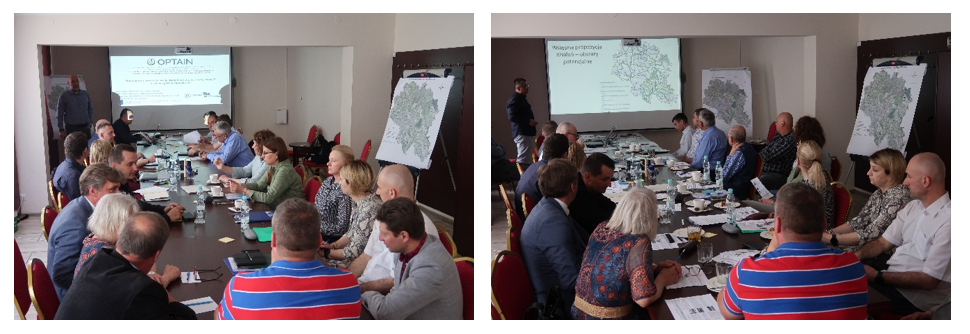
Fig. 8. The 2nd MARG workshop (May 2022) (M. Piniewski)
NSWRM priority selection A set of 10 pre-selected candidates for Upper Zgłowiączka NSWRMs were presented to MARG members. They were asked to prioritize them (Fig. 9) by selecting 5 most suitable measures from their point of view, assigning points from 5 (the most preferable) to 1 (the least preferable of these 5). Subsequently, it was confronted with the OPTAIN scientists’ list.

Fig. 9. MARG members preferences on NSWRMs for Upper Zgłowiączka case study (points – total number of allocated points; hits – by how many stakeholders the measure was selected)
Finally, the following NSWRM (Fig. 10) were selected for mathematical modelling of the catchment area of the Zgłowiączka River. Additionally, some of them will be included and described in WOCAT database.
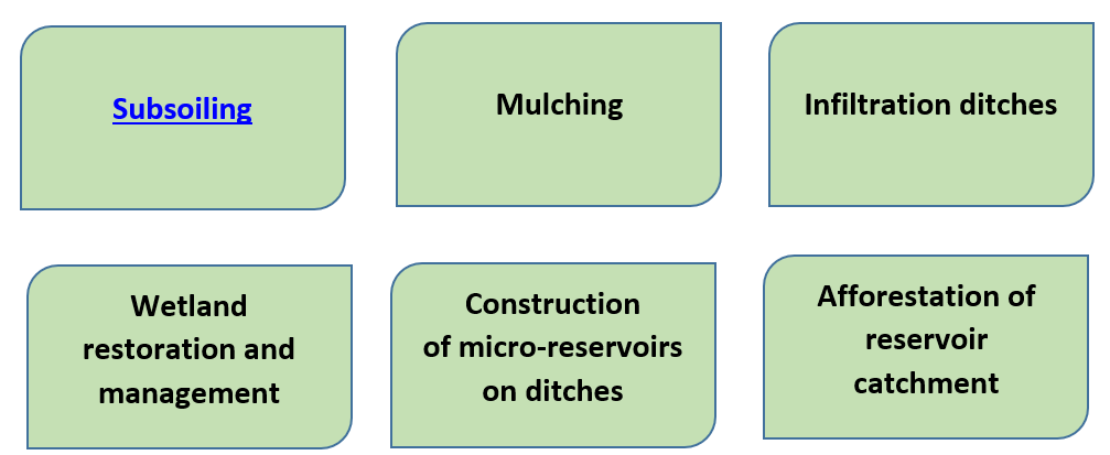
Fig 10. NSWRMs selected for mathematical modelling in the Upper Zgłowiączka case study

Fig. 11. Subsoiling (T. Bolewski)

Fig. 12. Mulching. Maize cultivated after maize. Shredded maize post-harvest residues and early development stage of young maize (W. Kasperska-Wołowicz)

Fig. 13. Field pond in the Zgłowiączka river catchment (Z. Miatkowski)

Fig. 14. Wetland restoration and management (I. Kardel)

Fig. 15. Afforestation of the reservoir catchment (B. Kowalski)
Allocation of the NSWRMAt the next meeting reasoning for allocation of measures and a map (Fig. 16) with proposed allocation was presented and discussed with MARG members. It resulted (Tab. 1) in set of preferred conditions for every measure, and information on current application practice of some measures in the case study.
Tab. 1. Preferable conditions and current practice for selected NSWRMs in the Upper Zgłowiączka case study


Fig. 16. Potential allocation of the NSWRMs in the Upper Zgłowiączka case study
Authors: Tymoteusz Bolewski, Ewa Kanecka-Geszke, Wiesława Kasperska-Wołowicz (ITP-PIB) & Marek Giełczewski, Ignacy Kardel, Mikołaj Piniewski - WULS-SGGW, Poland
****************
The Csorsza catchment is a small agriculturally dominated catchment, where Csorsza stream (Figure 1.) is part of the water network feeding Lake Balaton, Hungary. The catchment has a total area of 21 km2 and is located in the Upper-Balaton region. With oceanic and Mediterranean influences continental climate is dominant in this region usually hot and dry in summer season, cold in winter season with most precipitation events occurring during spring and fall months. The soils at the catchment are Cambisols and Calcisols. The region is regarded as moderately rain deficient, with high threat of soil erosion, flash floods, and nutrient load. The catchment has a high focus on integrated water resources conservation.
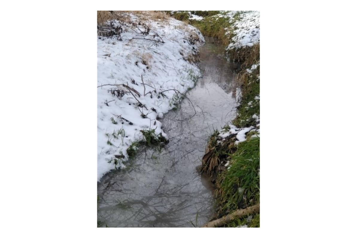 Figure 1. Csorsza stream during late winter.
The catchment mainly consists of forests, grasslands, croplands/pastures, and vineyards (Figure 2.). The research site has a long history of viticulture, mainly cultivated on medium to steep slopes, and soil erosion is therefore a major problem. In the vineyards the inter-row is i) grassed or ii) planted with cover crops such as mix of red clover and alfalfa or iii) tilled (Figure 3.). Due to its high susceptibility to erosion, the research site and its surroundings have soil moisture, soil temperature, and general meteorological data collection (e.g., precipitation, air temperature, wind sleep and direction, humidity, air pressure, solar radiation) since 2015 and soil-plant-water system related studies since 2019. Our monitoring system includes continuous and discrete measurements of soil physics (e.g., particle size distribution, soil moisture and temperature), soil chemistry (e.g., pH, nitrogen content, organic carbon, phosphorous), and plant trait (e.g., leaf chlorophyll, NDVI, leaf area index, PRI, PAR). Stream water measurements include chemistry (nitrite, ammonium, pH), and total suspended solids carried toward Lake Balaton (Figure 4.).
 Figure 2. Area of the Csorsza case study showing locations for continuous monitoring of soil water and temperature sensors, rain gauges, and the main meteorological station.
 Figure 3. Three main inter-row soil management systems generally used in vineyards, namely grassed, cover crops (red clover, alfalfa), or tilled inter-rows.
 Figure 4. Water pressure sensor (discharge measurements), water velocity, and water chemistry (YSI ProDSS) instruments used in study.
MARG meetingThe first MARG meeting was held online, while the second one was organized on-site in Szentantalfa, Hungary. All main stakeholder groups were well represented by the participants. One of the main outcomes of the MARG survey revealed that the most important environmental performance indicators were the sub-surface soil moisture, surface runoff, timing, frequency, intensity, and the duration of flooding for both field and catchment level. The potential locations of water retention measures were determined during the meeting based on the suggestions of local stakeholders (Figure 5.). The main challenges at the study catchment were drought (e.g., water deficits, frequency of drought conditions) (Figure 6.), for which the relevant possible measures were described and the benefits of using the right ones were discussed (mulch in vineyard, no-till soil management in croplands). Another main issue at the study catchment are flash floods, related to this problem advantages and disadvantages of swales, ponds, strip cropping along contours were discussed.
 Figure 5. a) The potential locations of the measures were determined based on the suggestions of the local stakeholders. The satellite map of the study was used to reveal the most problematic areas. b) Location of measures placed by the workshop participants. Different colors of the stickers indicate different water retention measures.
 Figure 6. Extreme drought conditions at the cropland site (sunflowers) in summer of 2022.
Authors: Agota Horel, Brigitta Szabó, Piroska Kassai, Kinga Farkas-Iványi, Tibor Zsigmond - Agrártudományi Kutatóközpont (ATK, Hungary)