

 Schwarzer Schöps
 Petite Glane
 Cechticky
 Cherio
 Dotnuvele
 Dviete
 Hobol
Hobol La Wimbe
 Pesnica
 Upper Zglowiaczka
 Sävjaan
Meet “Schwarzer Schöps” – German Case Study
The Quitzdorf Reservoir, Saxony’s largest reservoir in terms of area, has repeatedly made the local headlines in recent years [1, 2, 3]. Recurrent blue-green algae blooms and declining water levels during dry periods impaired the dam's function for local recreation, fishing and flexible control of downstream flows. The federal budget has earmarked 20 million euros for the complex renovation of the dam by the year 2026 [4]. However, there is a growing awareness that a sustainable solution to the problem must also strengthen the catchment's ability to effectively retain water and nutrients, especially phosphorus, which enters the river network through soil erosion. The German OPTAIN case study refers to the main catchment of the reservoir, an agricultural catchment of about 137 km², whose main river is the Schwarzer Schöps. Together with local stakeholders from different sectors (water, agriculture, nature and landscape conservation), we have selected and documented promising Natural/Small Water and Nutrient Retention Measures (NSWRM) [5, 6]; the effectiveness of which will be simulated with the integrated watershed model SWAT+ [7]. The routing of water and nutrient fluxes across the landscape through the model was extended in OPTAIN to allow a detailed assessment of the effectiveness of NSWRM at individual sites [8].
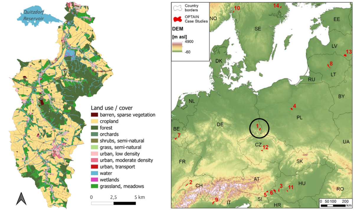
Location and land use of the German case study ‘Schwarzer Schöps’. Data sources: ATKIS land cover (modified) and AECS field boundaries from the year 2021
Which NSWRMs are investigated?
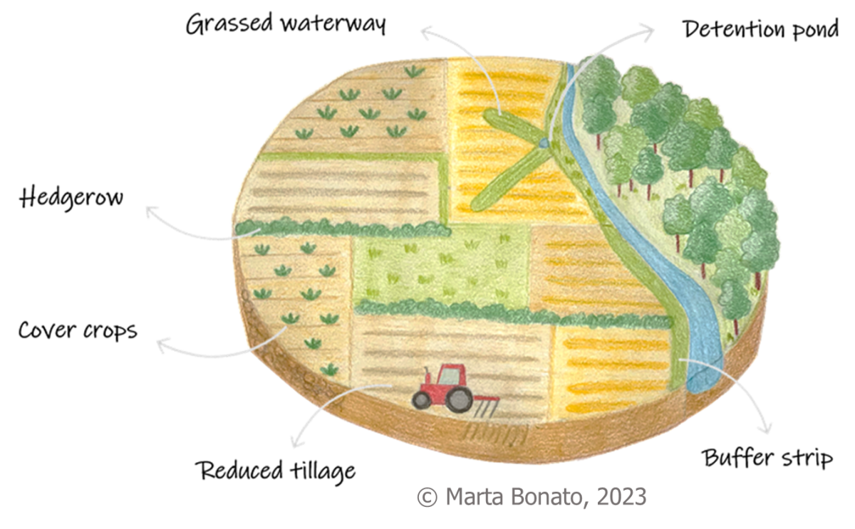
The most important types of NSWRMs for the German Multi-Actor Reference Group (MARG), which can also be modelled in the project, are riparian buffers, grassed waterways and hedgerows as linear landscape structures, and reduced tillage and cover crops as soil management practices. The OPTAIN team added detention ponds to the list of measures to also consider a more technical type of NSWRM.
The mapping of potential implementation sites for each type of NSWRM in the catchment was also carried out in close collaboration with the MARG and can be summarised as follows:
Grassed Waterways
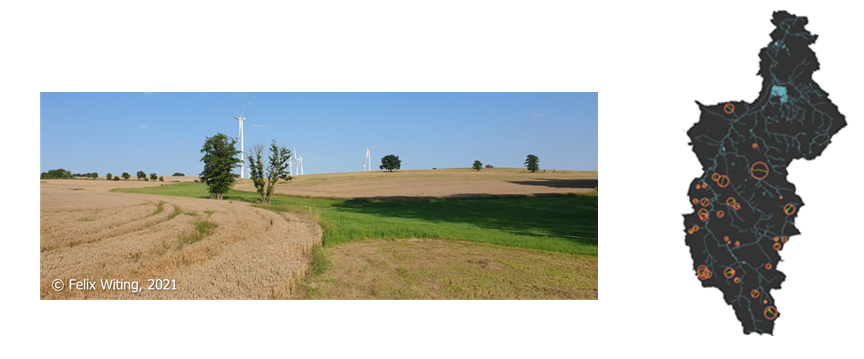
Where: Erosive slopes [9] in close distance/connection to river network (n=34).
Model assumption: Permanent grass strip of 30 m width.
Hedgerows
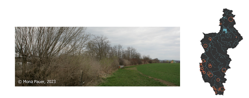
Where: In fields with exceptionally low density of semi-natural habitats (SNH) in the surrounding area, if possible along contour lines and connecting existing SNH (n=28).
Model assumption: Deciduous forest strip of 15 m width; pruning every 5 years.
Grassed riparian buffer
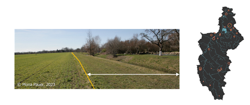
Where: Fields without existing ‘green’ buffer along streams (n=30).
Model assumption: Permanent grass strip of 12 m width (towards the center of the channel/stream).
Low tillage combined with cover crop
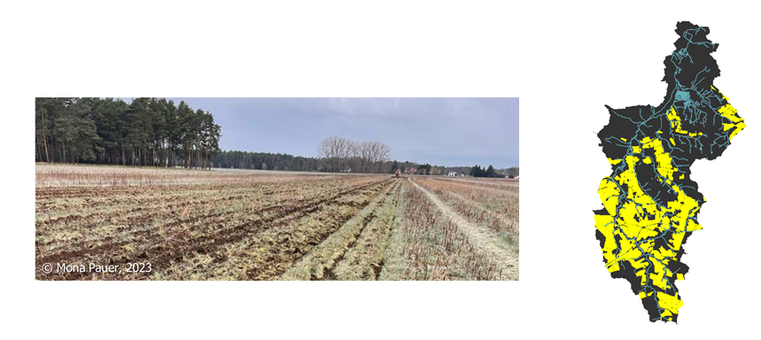
Where: Fields with high potential erosion risk (on average > 15 t/ha,a) according to LfULG risk map (31% of total area) [10].
Model assumption: Lower tillage depth (max. 12 cm), no autumn furrow, instead winter cover crop before corn, sugar beet or spring barley
Detention ponds
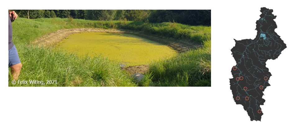
Where: At the end of erosive slopes with close connection to streams and a minimum drainage area of 50 ha (n=9).
Model assumption: Depending on site, principal volume of 700-1700 m³ and emergency volume of 1300-3200 m³; drawdown from emergency to principal spillway within 2 days.
We modelled scenarios for each type of NSWRM and a combined scenario, assuming that all measures were implemented simultaneously. Simulations were performed for both the current climate and the future climate projected by EURO-CORDEX, considering six downscaled and bias-corrected Regional Climate Models (RCMs), three Representative Concentration Pathways (RCPs 2.6, 4.5, and 8.5) and three time slices (historical – 1991-2020, near future – 2036-2065, far future – 2071-2099). The modelling results of all OPTAIN case studies (where available) are reported in project Deliverable 4.4 [8]. They are briefly summarized below for the German case study.
Low tillage, combined with cover crops, and grassed waterways were found to be the most effective NSWRMs.
The results show that NSWRMs can be very effective in retaining phosphorus (P) in the catchment area. A model scenario in which all six types of NSWRM are implemented simultaneously at all potential sites would reduce P losses from agricultural land by ~40% and reduce the average P river load to the Quitzdorf Reservoir by up to 1800 kg per year. This is an extreme scenario revealing the maximum possible retention potential of NSWRMs in the Schwarzer Schöps catchment. The performance of NSWRMs varied strongly between sites, indicating that cost-efficient solutions need to consider spatially targeted NSWRM implementation schemes.
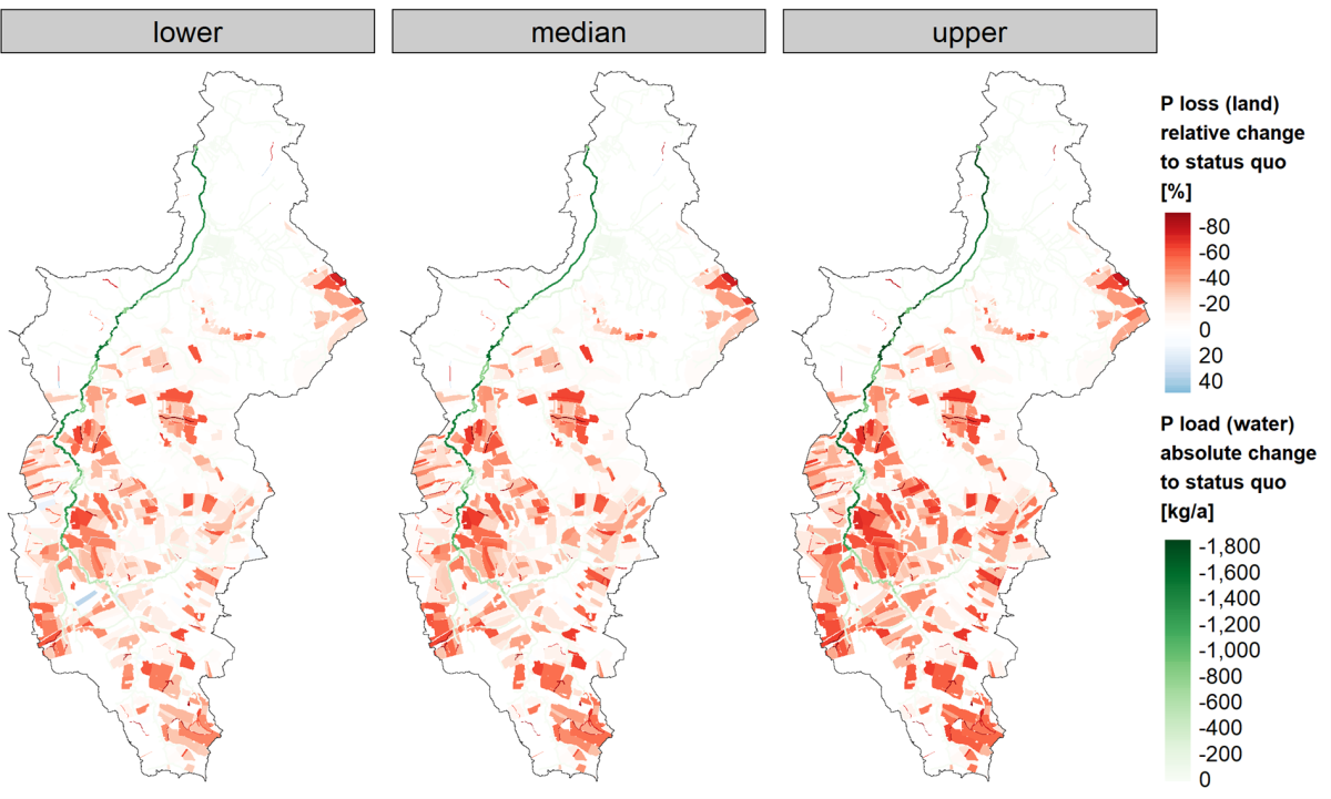
Simulated changes in average annual P loss on land units (HRUs) and changes in P load in water bodies (channels and reservoirs) in the Schwarzer Schöps catchment under scenario ‘all’ (all NSWRMs implemented simultaneously at all potential sites) compared to the status quo (current situation). Shown are the median and lower and upper bounds of a model ensemble with ten different parameterisation schemes that proved to be the best performing during model calibration.
We also ran model scenarios for each type of NSWRM and found that low tillage in combination with cover crops is the only effective option for retaining water in the catchment area. This management practice can help to increase the available soil water content, but also the low flows during dry periods, while substantially reducing peak flows at the catchment outlet. All measures can contribute to sediment and P retention, but to varying degrees. The combination of low tillage and cover crops is again the most effective scenario, followed by grassed waterways and riparian buffers, while hedgerows and detention ponds had only a marginal effect. The impact on catchment-scale crop yields was rather small, with changes of less than 1% compared to the status quo.
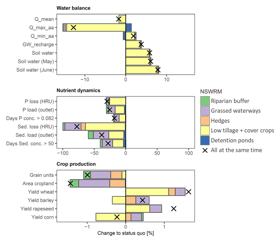
Simulated impact of different types of NSWRM on the catchment’s water balance, nutrient dynamics and crop production. Shown are median values of the model ensemble. Q_mean is the mean discharge, Q_max_aa is the average annual maximum discharge and Q_min_aa is the average annual minimum discharge at the catchment outlet. GW_recharge is the total amount of groundwater recharge. More details are available in Deliverable 4.4 [8].
Future climate is predicted to be wetter in winter and spring, resulting in higher P loads. NSWRM can mitigate and even reverse this effect.
The ensemble of six regional climate models predicts a significant warming trend for the Schwarzer Schöps catchment (temperature increase of 1-5°C by the end of the century, depending on the assumed RCP), with small seasonal differences (less in spring, higher in autumn and winter). An increase is also predicted for precipitation, especially for RCPs 4.5 and 8.5 in winter and spring [11].
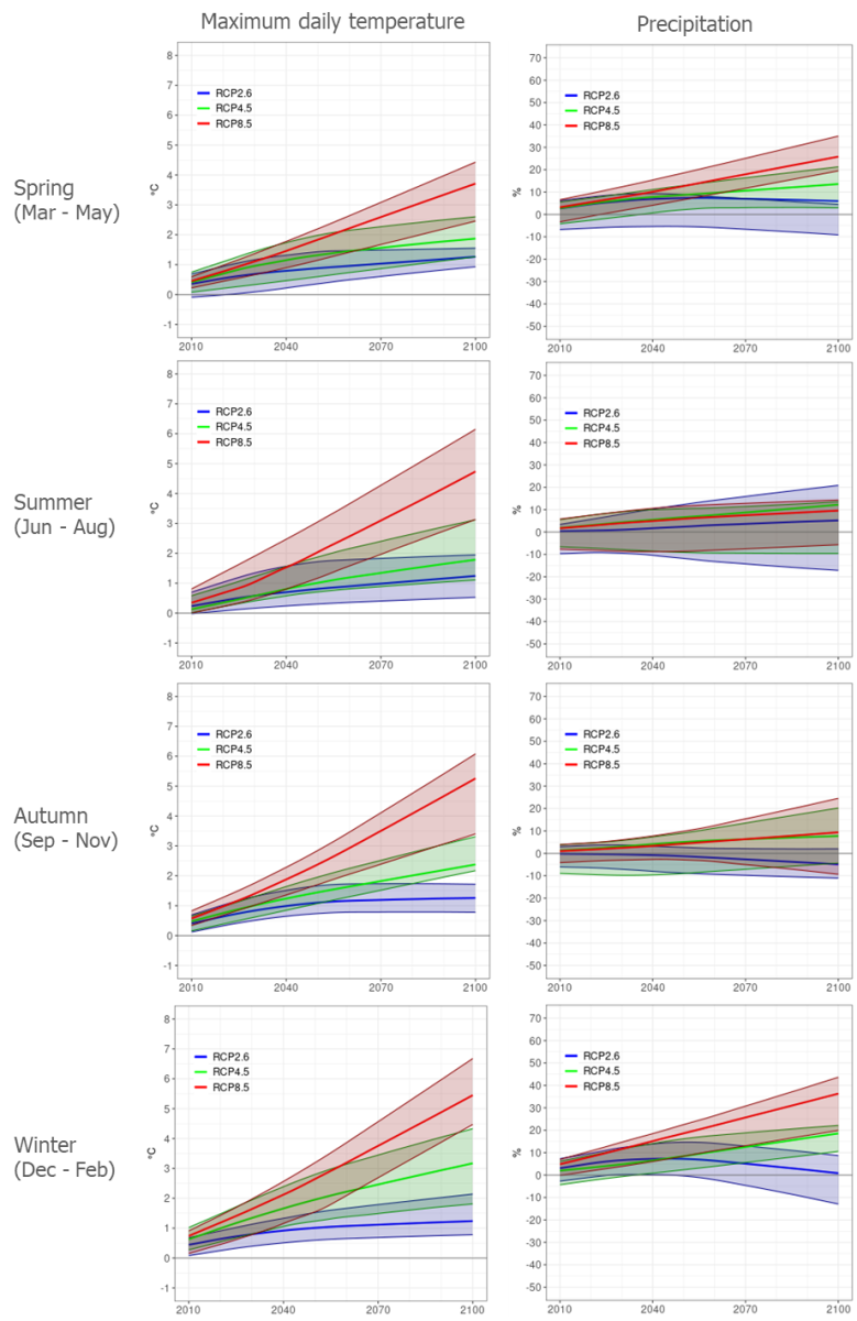
Annual average daily maximum temperature and annual precipitation projected for the Schwarzer Schöps catchment by the end of this century. Shown is the ensemble mean and spread of six regional climate models (RCMs) for different Representative Concentration Pathways (RCPs). Source: Honzak and Pogačar (2022) [11]
Climate change is expected to increase the frequency of extreme weather and hydrological events in Europe, jeopardising water retention and quality. The SWAT+ model simulations for the German case show that in most case the magnitude of high flow events and nutrient losses will actually increase [8]. It is therefore of great practical importance to assess the effectiveness of measures under future climate. To limit the modelling effort and for illustrative purposes, three different climate scenarios were selected from the ensemble of available RCP-RCM combinations, representing a 'cool & dry', a 'cool & wet' and a 'warm & wet' scenario, respectively. The wet scenarios assume higher rates of precipitation, resulting in increased discharge at the catchment outlet. While the increase in low-flow discharge (indicated by an increase in Q_min_aa) can be seen as a positive development, the general increase in discharge and especially the high flows (Q_max_aa) lead to higher P loads entering the Quitzdorf Reservoir. The good news is that, according to our model results, P loads can be reduced by implementing the NSWRMs even under the projected climate change. This would require a combination of low tillage with cover crops and grassed waterways on fields with high soil erosion risk.
NSWRM effectiveness in the Schwarzer Schöps catchment under three different climate scenarios.
With the new routing approach, OPTAIN is breaking new ground in integrated catchment modelling. Even though the model allows a spatially explicit assessment of the effectiveness of NSWRMs, the approach still has some shortcomings, which were presented and discussed last month (July 2024) at the International SWAT Conference in Strasbourg, France [12]. For example, surface runoff is generally simulated as sheet flow (rather than channel flow), which fully infiltrates into the receiving land units, which may then become too wet. The model results should therefore be treated with the utmost caution.
Authors: Michael Strauch, Felix Witing, Martin Volk